North Korea’s political prison camps – which the regime denies even exist – are referred to by their number, as in Camp XX. According to Daily NK reports, North Korea had six political prison camps as of June 2023: Camp 14 in Kaechon, Camp 15 in Yodok, Camp 16 in Hwasong, Camp 17 in Kaechon, Camp 18 in Pukchang and Camp 25 in Susong. These camps housed 198,900 people.
In recent nighttime Visible Infrared Imaging Radiometer Suite (VIIRS) images, I detected lights at Camp 22 in Hoeryong, North Hamgyong Province, a camp which has been reported closed since June 2012. Using Google Earth imagery, I zoomed in on the area around the camp and examined its nighttime lights and key areas.
The Camp 22 area and its nighttime appearance

Hoeryong is the hometown of veteran actor Lee Soon-jae. Camp 22 covers the Chungbong district and Haengyong village of Hoeryong. Ahn Myeong-cheol, executive director of NK Watch and general secretary of the Committee for Human Rights in North Korea, worked as a prison guard there. The camp is a completely restricted area, notorious for its high mountains, deep valleys and tight patrols – once inside, not even your spirit can escape after you die. Ahn exposed the horrific conditions there to the world for the first time. The camp covers an area of 22,380 hectares, about 77 times the size of Seoul’s Yeouido. According to Ahn’s lectures on YouTube, the camp had a crematorium where authorities burned the bodies of dead prisoners (marked with a star in the image to the right).
Nighttime VIIRS images showed lights in three locations. I zoomed in on these three locations – two in the villages of Haengyong and Saul, and one on the outskirts of Kungsim – to examine them more closely.
Lights of Camp 22 at night

This VIIRS image of Camp 22, taken at 1:30 AM on Mar. 5, shows lights in three locations. The photo shows light emanating from reclaimed agricultural fields on a hillside in an area near the crematorium in Haengyong Village. Light was also seen emanating from hillside fields in Saul Village. In addition, light was detected emanating from an empty hillside on the outskirts of Kungsim Village. Lights emanating from hillside agricultural fields at night suggest that people are working day and night or engaged in some other unknown activity.
Camp 22 was reportedly closed in June 2012. According to Daily NK, the camp was closed because Hoeryong – the birthplace of anti-Japanese revolutionary Kim Jong Suk, mother of late North Korean leader Kim Jong Il and grandmother of current leader Kim Jong Un – is a sacred historical site and therefore unfit to house a political prison camp full of reactionary criminals. On the other hand, some people claim that North Korea did not close the camp, but merely disguised it to evade firm demands from the international community, including the U.N., to open the camp for inspections. Zooming in on the Google Earth image, I can see the remains of a fence on the outskirts of the camp. It is difficult to determine whether the camp is truly closed based on satellite imagery alone.
Changes in Haengyong village housing after the camp’s closure

Looking at the residential area of Haengyong Village in 2011, before the camp was closed, we see small, house-like dwellings for inmates scattered here and there. It’s also possible to see workplaces, a furniture factory, a threshing floor, grain storehouses and other facilities. There’s also administrative facilities such as a command room, an interrogation room, and a transportation department. To determine what these facilities are, I referred to the satellite analysis materials released by the Committee for Human Rights in North Korea on October 22, 2012.
Let’s compare this to a satellite image taken 11 years later, in May 2023, after the camp was closed. About 20 buildings have been demolished, including prisoners’ quarters, workplaces, and especially the interrogation room. On the other hand, about 10 new buildings were built. The Haengyong Stream flows through the village, flanked by agricultural fields. Agricultural activity can also be seen as farmers prepare seedbeds and water their fields before the spring planting season in early May. Comparing the two images, some of the facilities appear to have changed, with old buildings demolished and new ones built, but the farming and other highland agricultural work continues unabated.

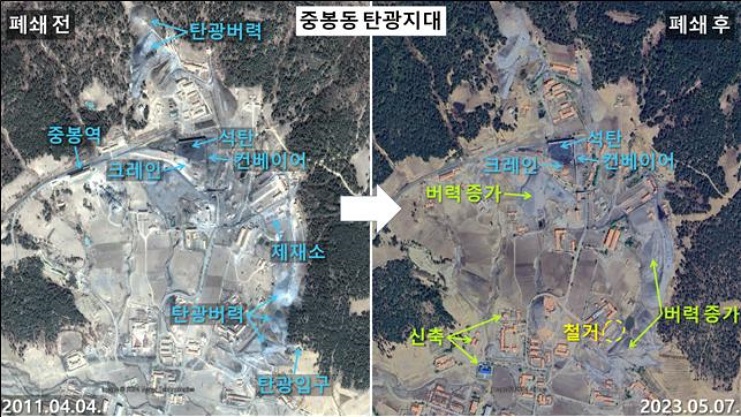
A mining zone is located in the Chungbong district within Camp 22. There is a train station where coal is loaded onto trains, and we can see a sawmill where wood is turned into lumber. We can also see a conveyor belt and crane in the coal storage area, and spoil piles – discarded excavated material – near the mine entrance. The satellite image, taken 11 years later, shows that some buildings have been demolished or rebuilt. At the same time, the spoil piles have grown into tall mounds, indicating that while the prisoners may have left, mining activity continues.
After Camp 22 was closed, the authorities reportedly moved the prisoners to other locations while civilians moved in. However, because it is still possible to see an outer fence in satellite imagery, I cannot confirm that the camp has been closed. We did confirm that the facilities have changed, with dozens of buildings, such as detention and interrogation facilities, demolished and new ones built. We also observed that the mining and farming activities that were carried out by the prisoners in the past continue unchanged, albeit now carried out by migrants to the area.
Translated by David Black. Edited by Robert Lauler.
Views expressed in this guest column do not necessarily reflect those of Daily NK. Please send any comments or questions about this article to dailynkenglish@uni-media.net.


