
Satellite analysis of North Korea’s crop conditions in August 2026 shows farmland across the country growing at almost exactly the same pace as last year, pointing to a harvest roughly in line with 2025 as the country continues to struggle with chronic food shortages.
I analyzed vegetation index data from the Joint Polar Satellite System (JPSS), a series of weather satellites operated by the U.S. National Oceanic and Atmospheric Administration (NOAA) and NASA, to assess the health of North Korean crops this year. The data, distributed by the U.S. Geological Survey (USGS) as eVIIRS NDVI, showed only a marginal rise in the peak August vegetation index on North Korean farmland. This indicates that overall crop vigor has held at about the same level as a year earlier.
The Normalized Difference Vegetation Index (NDVI) gauges how much healthy green vegetation covers an area by comparing how plants reflect visible and near-infrared light. Values closer to 1.0 indicate denser and more vigorous plant growth, which makes NDVI a standard tool for tracking crops from space.
Favorable weather helped this year, as reservoirs held enough water in the spring and the summer brought plenty of sunlight. However, chronic shortages of farming supplies, combined with an August heat wave and drought that hit dryland crops, kept North Korea from achieving any major gains in productivity.
Taken together, these factors suggest that North Korea’s 2026 harvest will look much like last year’s. The final yield could still shift, however, depending on whether autumn typhoons or floods strike first. In the fall of 2025, typhoons bypassed the Korean Peninsula, and the harvest turned out relatively better than the year before. If the country avoids major typhoon damage again this year, I expect it to maintain a stable harvest on par with last year’s.
Food production remains a pressing issue for the Kim Jong Un regime, which has repeatedly pressed farms to boost grain output.
Mapping crop conditions across 1.9 million hectares
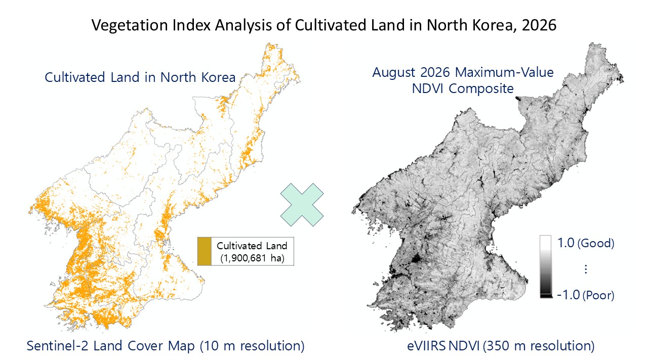
To assess crop conditions in August 2026, I combined a land use map based on the European Space Agency’s Sentinel-2 satellites with eVIIRS imagery. I extracted North Korea’s cultivated land from the 2025 global land use map produced at a 10-meter resolution by ESRI, a U.S. geographic information systems company. That data puts North Korea’s total farmland at about 1.9 million hectares. Overlaying the eVIIRS imagery on this farmland data gave me a framework for tracking how well crops are growing.
I built the vegetation index data using maximum value compositing (MVC), a technique that keeps only the highest readings from a set of images. In this case, I drew on eVIIRS data observed at a 350-meter resolution throughout August 2026. This process filters out interference from clouds and shadows so that the composite reflects only vegetation vigor. Crop vegetation index values generally peak close to 1.0 in mid-August, when growth is most active, and then gradually decline until harvest. For this reason, the August maximum value composite serves as a reliable benchmark for judging the state of the crops.
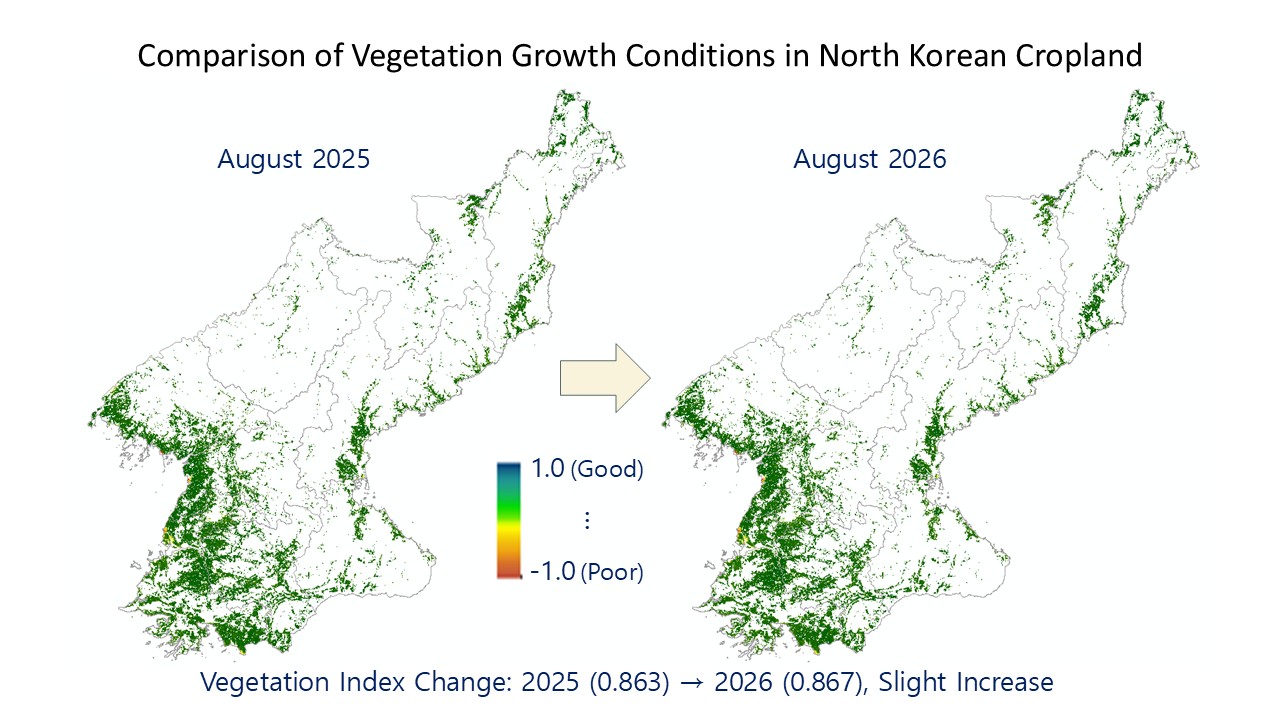
Using this refined satellite data, I compared vegetation changes against the same period last year. North Korean farmland recorded a vegetation index of 0.867 in August 2026, slightly higher than the 0.863 measured in August 2025. A change of 0.004 falls within the margin of error for satellite data analysis, meaning that North Korean crops are growing in a similar environment and with similar vigor to last year.
Net gains cover just 6.4% of North Korean farmland
To pinpoint how vegetation changed between August 2025 and August 2026, I ran a change detection analysis in ERDAS IMAGINE 2022, a professional image processing program. I used the program’s image differencing function to handle this step. This method subtracts one period’s vegetation index image from the other to calculate the numerical difference between the two.
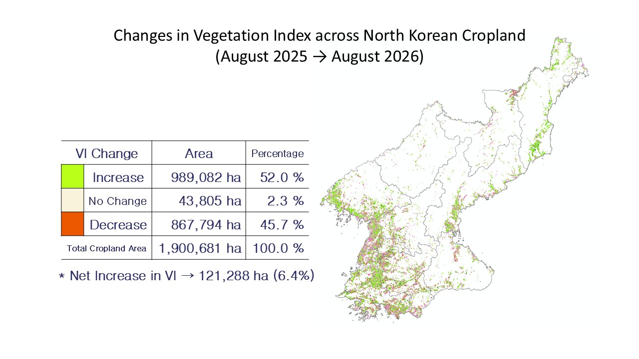
The area where the vegetation index increased totaled 989,082 hectares, or 52.0% of all farmland, slightly exceeding the 867,794 hectares (45.7%) where it declined. The net increase, however, came to just 121,288 hectares, or about 6.4% of North Korea’s total cultivated land. While the share of land where crops improved on last year grew slightly, overall conditions remain largely unchanged from 2025.
This year’s results reflect a mix of weather and farming conditions over the course of the growing season. In the spring, water stored in reservoirs across major grain-producing regions allowed rice transplanting to proceed smoothly. Abundant summer sunlight later helped the rice grains ripen as well. Chronic shortages of fertilizer, pesticides and fuel, along with aging irrigation facilities, limited any significant improvement in productivity, however. Heat waves and short-term drought also stunted the growth of some dryland crops, producing a degree of variation between regions and crop types.
Satellite observations show North Korea’s 2026 crops tracking last year’s trend, but autumn weather will decide the final yield. North Korea’s drainage infrastructure is weak, so typhoons or torrential rain during the late ripening stage of rice could flood fields and flatten crops. Fortunately, typhoons skirted the Korean Peninsula in the fall of 2025, sparing crops from major damage and producing a better harvest than in 2024. The final outcome of North Korea’s farming year will likewise depend on whether autumn typhoons strike the country before the harvest is in.
This article was originally written in Korean and translated with the help of generative AI tools. It was then edited by a native English-speaking editor. All AI-assisted translations are reviewed and refined by our newsroom.