

A powerful downpour that swept across North Pyongan province on Aug. 24 triggered a major flooding crisis in the Sinuiju area for the second time in as many years, satellite imagery reveals.
Radar satellite analysis of images captured at 6 p.m. on the day of the storm shows the Yalu River and the Samgyochon Stream overflowed simultaneously, submerging a total of 740 hectares — approximately 2.6 times the size of Yeouido — across the Sinuiju, Uiju and Pihyeon areas. The heaviest damage concentrated in the Uiju Airfield, which lacks external dikes, before spreading to the Pongwha Chemical Plant, a critical national oil facility, surrounding areas near North Korea’s customs office, low-lying zones in Sinuiju’s urban center and other key infrastructure throughout the region. Given that satellite imagery’s resolution of approximately 10 meters cannot capture flooding smaller than one hectare, the actual damage extent likely exceeds these estimates.
Cleanup struggles as sediment pours downstream
Four days later, on Aug. 27, optical satellite imagery showed the Samgyochon Stream remained murky with sediment and silt from upstream reservoirs at Paekma and Kumgang, indicating drainage delays. The sediment accumulation and poor drainage conditions are hampering cleanup around the Pongwha Chemical Plant and slowing water removal along the customs office access roads, suggesting secondary damage and restoration delays will be prolonged.
Satellite imagery also illuminated stark differences in damage severity based on preparedness. The Uiju Airfield runways and taxiways remain buried under thick mud and sediment layers, threatening aircraft operations. Restoration will require extensive excavation and resurfacing work. In stark contrast, the Wihwado greenhouse complex, protected by embankments and water barriers, avoided major losses. The disparity underscores how flood prevention infrastructure can mean the difference between survival and catastrophe.
Flood damage on the ground
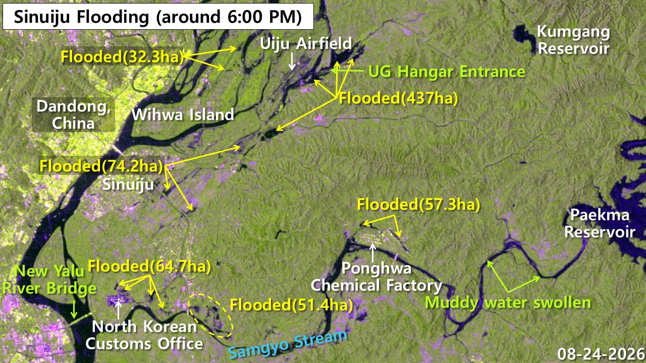
On Aug. 24, the simultaneous overflowing of the Yalu River and the Samgyochon Stream inundated broad swaths of Sinuiju and Uiju. The heaviest concentrations of damage struck the Uiju Airfield, the Pongwha Chemical Plant’s outer zones, areas surrounding North Korea’s customs office and low-lying neighborhoods in downtown Sinuiju, according to satellite analysis.
The Aug. 24 radar imagery showed that flooding from the synchronized breaching of the Yalu River and Samgyochon Stream spread across 740 hectares in the Sinuiju, Uiju and Pihyeon areas — 2.6 times the area of Yeouido. The analysis identified the Uiju Airfield as the hardest hit, with 437 hectares of the base and surrounding farmland engulfed. Major flooding also struck the Pongwha Chemical Plant’s exterior (57.3 hectares), the North Korean customs office perimeter (64.7 hectares), the lower Samgyochon Stream (51.4 hectares) and low-lying urban zones in Sinuiju (74.2 hectares) — all critical economic and logistics hubs.
Four days after the deluge, Sinuiju remained waterlogged. The Samgyochon Stream, swollen with sediment from upstream Paekma and Kumgang reservoirs, remained a murky tan color as drainage crawled forward. The Uiju Airfield was buried under thick layers of mud and sediment, threatening normal operations. The Wihwado greenhouse complex, fortified with dikes, escaped major losses.
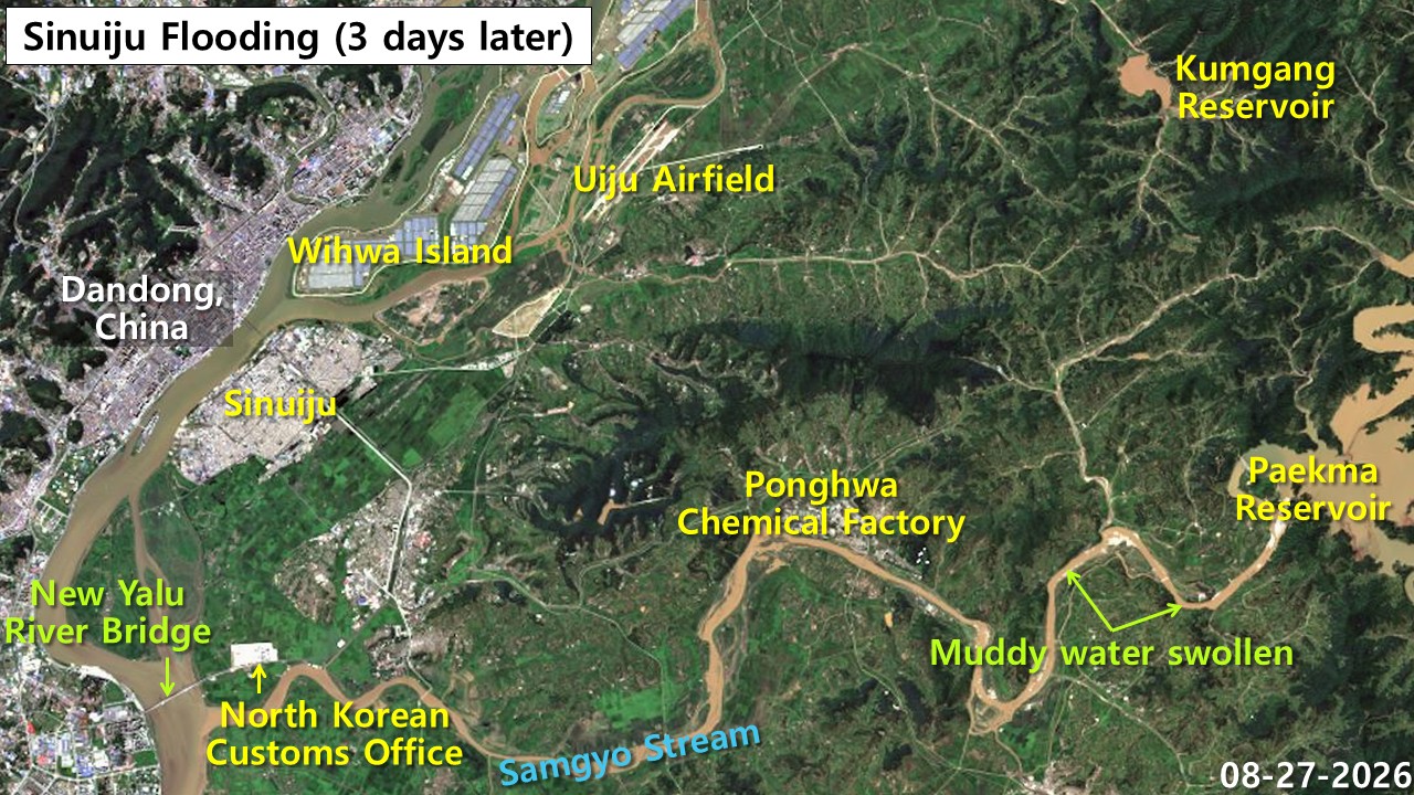
Analysis of optical satellite imagery on Aug. 27 showed that four days after the torrential downpour, the Samgyochon Stream still ran thick with sediment from upstream sources, delaying drainage in downstream low-lying areas. The Pongwha Chemical Plant’s southern perimeter remained flooded with muddy water, and drainage roads around the customs office were progressing slowly. The Uiju Airfield runways and taxiways remained buried under thick layers of mud and sediment, indicating serious operational disruptions ahead. Meanwhile, the Wihwado greenhouse complex, protected by embankments, showed minimal damage — revealing sharp disparities in harm based on the presence or absence of flood defenses.
Uiju Airfield
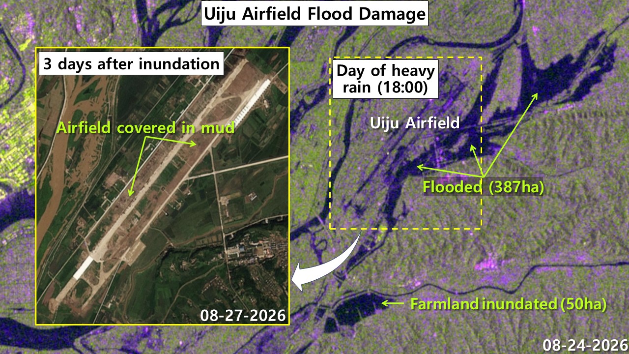
Radar satellite imagery from the day of the deluge shows the Uiju Airfield was massively inundated due to the absence of outer embankments protecting the facilities. By Aug. 27, satellite images showed runways completely covered in mud and sediment, requiring extensive excavation to restore operations.
On Aug. 24, the absence of protective embankments around the Uiju Airfield allowed the facility itself (387 hectares) and adjacent farmland (50 hectares) — totaling 437 hectares — to be engulfed. Four days later, on Aug. 27, photographs showed runways, taxiways and aircraft parking areas blanketed in thick mud and sediment deposits. Foreign object debris entering engines and reduced braking effectiveness pose serious safety hazards that will severely disrupt aircraft operations. Airfield restoration will require excavation, cleaning and repairs to runways, taxiways and navigation systems — work estimated to take several days.
Bongwha Chemical Plant
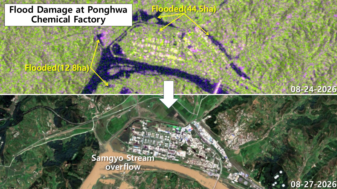
The Pongwha Chemical Plant’s perimeter experienced flooding on the day of the deluge, concentrated in outer zones and low-lying areas. By four days later, the swollen Samgyochon Stream, now thick with silt, was flooding the plant’s southern perimeter and adjacent facilities, threatening operations and safety protocols.
As water levels rose sharply in the Samgyochon Stream – which originates at Paekma Reservoir – a total of 57.3 hectares of low-lying terrain directly outside North Korea’s most critical oil facility, the Pongwha Chemical Plant (44.5 hectares), and the plant’s western access road (12.8 hectares) submerged. By Aug. 27, the sediment-choked Samgyochon overflowed onto the plant’s southern sector and right up to critical facilities. Delayed drainage and possible stream backflow have severed the access road, threatening not only logistics transportation but also underground pipes, power cables and pump stations — creating secondary flood risks. Emergency reinforcement of embankments and facility repairs appear essential for resuming normal operations.
North Korean customs office

The customs office area, a junction for the new Sino-Korean bridge, experienced flooding of surrounding areas on the day of the deluge – specifically the zone north of the office, roads to the east and low-lying terrain southeast of the Samgyochon Stream. Four days later, drainage remained slow due to the silt-laden stream, potentially delaying preparations for the new bridge’s opening.
The Aug. 24 flooding submerged a total of 64.7 hectares around the North Korean customs office area serving as the connection point for the new Sino-Korean bridge — including the zone north of the office (18.6 hectares), the eastern connecting road (13.4 hectares) and low-lying terrain southeast of the Samgyochon Stream (32.7 hectares). The customs office compound itself, situated on relatively well-developed high ground, escaped direct inundation. However, by Aug. 27, the silt-laden stream delayed water removal from outer roads and surrounding farmland. With the customs building and main bridge access road intact, there appear to be no major delays to the opening schedule. However, debris cleanup on outer roads, inspection of underground conduits and dredging of stream sediment will inevitably cause a few days of additional delays to opening preparations.
Damage summary by region
Radar satellite analysis of imagery captured at 6 p.m. on Aug. 24 shows the total flooding damage across Sinuiju and Uiju reached 740 hectares — roughly 2.6 times the area of Yeouido. Satellite imagery’s 10-meter resolution prevented identification of smaller inundated areas under one hectare or waterlogged zones near minor drainage channels. The actual on-the-ground flooding extent likely exceeds these figures when smaller submerged areas are included.